The wine-growing region is located in Rhineland-Palatinate and a small part of Saarland in Germany. The Moselle river meanders 237 kilometres from Trier to Koblenz, but is only 96 kilometres as the crow flies. The vineyards cover 8,798 hectares of vines, stretching along the Moselle from its source in the Vosges mountains on the border with Luxembourg to its confluence with the Rhine near Koblenz, as well as along the two tributaries Saar and Ruwer. These three rivers gave the growing region its old name, Mosel-Saar-Ruwer, which was valid until 2007.
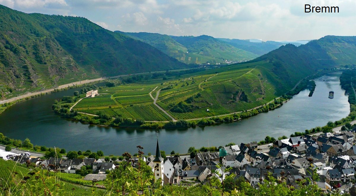
The picture shows a view of the Moselle with the municipality of Bremm (Cochem Castle) from single vineyard Calmont.
Germany's oldest vineyards
The oldest vineyards in Germany are located on the upper Moselle. The Romans were already cultivating vines here in the 1st century BC and founded the city of Augusta Treverorum, today's Trier, in 15 BC. The remains of old Roman presses can still be seen in Piesport and Erden. The Neumagen wine ship is also a reminder of Roman wine culture. The two Roman poets Ausonius (310-395) and Venantius Fortunatus (530-610) described the beauty of the landscape during boat trips on the Moselle. In the Middle Ages, the Benedictine order owned many vineyards along the banks of the three rivers, as evidenced by the many individual vineyard names.
Real division under Napoleon
The French Emperor Napoleon Bonaparte (1769-1821) enacted a law after occupying this region in 1807, the negative effects of which can still be felt today. In order to prevent large-scale land ownership, he decreed the "real division", by which land ownership was to be divided equally among all descendants in the event of inheritance. The result was a fragmentation into countless, often extremely small land units. At the Congress of Vienna in 1815, the former Electorate of Trier territory was incorporated into the Prussian state.
Prussian land classification
Subsequently, the royal government introduced various measures to improve the economic situation of Moselle winegrowers. These included the Prussian classification of vine yard sites, the founding of the winegrowers' association and the establishment of three winegrowing domains on the Moselle and Saar, which ushered in a heyday of Moselle viticulture. This continued the tradition of the great wine lover King Frederick the Great (1712-1786), who had a vineyard planted on the southern slope of the Klausberg in Park Sanssouci in Potsdam in 1769.
Climate & soil
The growing region is one of the warmer climate zones in Germany. Like all bodies of water, the Moselle has a positive effect or creates the conditions for this by forming valley slopes. Viticulture benefits from the ideal combination of steep, sun-drenched slopes, sun-reflecting slate soils and optimal rainfall. On some steep slopes, cultivation is only possible using special equipment and monorack tracks. Calmont is one of the steepest vineyards in the world with a gradient of up to 68°.
There are only slight temperature fluctuations. The climate is characterised by pleasantly warm summers and only moderately cold winters with hardly any frost. The soils consist of shell limestone and Keuper in the upper Moselle, and Devonian and dark clay slate in the middle and lower Moselle and in the Saar and Ruwer valleys. The slate stores the sun's heat during the day and releases it again at night, which makes for a mild climate. The vines are usually rooted metres deep in the soil or rock.

Areas, municipalities and sites
Many small winegrowers work the often terraced steep slopes with painstaking manual labour and deliver their grapes to large wineries. Mosel is divided into six areas with 19 large vineyards and 524 individual vineyards. The 242 kilometre-long Moselle Wine Route begins directly behind the German-French border in Perl, runs alongside the river and crosses it several times. It touches many famous wine-growing communities along the way and ends in Koblenz.
The German wine law allows the area name to appear on the label without the addition of "Bereich", provided there are no place names or single vineyard designations that could cause confusion. The winegrowers from the "Saar" had already practised this since the name change, but this was not possible for those on the "Ruwer". In 2019, vineyards with the part of the name "Ruwer" in the district of Trier-Ruwer that are no longer cultivated were deleted from the vineyard register, allowing them to be listed on the label.
Bernkastel (Middle Moselle)
The area Bernkastel or Mittelmosel (formerly Untermosel) forms the centrepiece with the most vineyards. It stretches from Briedel in the north upstream to the Moselle metropolis of Trier in the south over a length of around 50 kilometres. The Moselle flows through the area in ten relatively narrow loops. The large area covers almost 6,000 hectares of vineyards and is divided into ten large vineyards: Badstube, Kurfürstlay, Michelsberg, Münzlay, Nacktarsch, Schwarzlay, St. Michael, Probstberg, Römerlay and Vom heißen Stein.
The most famous Moselle communities and vineyards are located here. Bernkasteler Doctor is one of the most famous single vineyards in the area and also in Germany. It belongs to the renowned Großlage Badstube with (unusually) exclusively first-class sites. Most of the deep soils consist of dark blue, weathered Devonian slate, often with a high stone content; in the municipality of Ürzig there is also Rotliegendes (red sandstone). The best-known wine-growing communities with their individual vineyards:
- Avelsbach: Altenberg, Hammerstein, Herrenberg, Kupp, Rotlei
- BernkastelAlte Badstube am Doctorberg, Bratenhöfchen, Doctor, Graben, Johannisbrünnchen, Kardinalsberg, Lay, Matheisbildchen, Rosenberg, Schlossberg, Stephanus-Rosengärtchen, Weisenstein
- BraunebergJuffer, Juffer Sonnenuhr, Kammer, Klostergarten, Mandelgraben
- Briedel: Herzchen, Nonnengarten, Schäferlay, Schelm, Weisserberg
- Castles: Bischofstein, Hasenläufer, Kirchberg, Römerberg
- Detzem: Maximiner Klosterlay, Würzgarten
- Enkirch: Batterieberg, Edelberg, Ellergrub, Herrenberg, Monteneubel, Steffensberg, Weinkammer, Zeppwingert
- Erden: Bußlay, Herrenberg, Prälat, Treppchen (Herzlei)
- Graach: Abtsberg, Domprobst, Himmelreich, Josephshöfer
- Kesten: Herrenberg, Paulinsberg, Paulinshofberger
- Kinheim: Hubertuslay, Römerhang, Rosenberg
- Klotten: Brauneberg, Coreidelsteiner Castle, Rosenberg
- Klüsserath: Brotherhood
- Köwerich: Held, Laurentiuslay
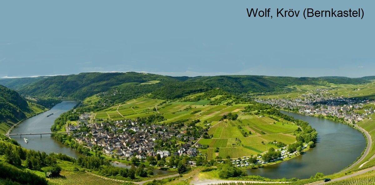
- KrövBurglay, Herrenberg, Kirchlay, Letterlay, Paradies, Steffensberg
- Leiwen: monastery garden, Laurentiuslay
- Lieser: Niederberg-Helden, Rosenlay, Schlossberg, Süßenberg
- Longuich: Herrenberg, Hirschlay, Maximiner Herrenberg
- Lösnich: Burgberg, Försterlay
- Maring-Noviand: Honigberg, Klosterberg, Lambertuslay, Römerpfad, Sonnenuhr
- Mehring: Blattenberg (with Layet cadastral site ), Goldkupp, Zellerberg
- Mülheim: Amtgarten, Elisenberg, Helenenkloster, Sonnenlay
- Neumagen-DrohnEngelgrube, Großer Hengelberg, Häs'chen, Hofberger, Laudamusberg, Nußwingert, Rosengärtchen, Sonnenuhr
- Piesport: Domherr, Falkenberg, Gärtchen, Goldtröpfchen, Grafenberg, Günterslay, Hofberger, Kreuzwingert, Schubertslay, Treppchen
- Pölich: Held
- Pünderich: Goldlay, Marienburg, Nonnengarten, Rosenberg
- Reil: Falklay, Goldlay, Mullay-Hofberg, Sorentberg
- Thörnich: Enggaß, Ritsch, Schießlay
- Treis: Greth, Kapellenberg, Treppchen
- Trier: Altenberg, Andreasberg, Augenscheiner, Benediktinerberg, Burgberg, Deutschherrenberg, Deutschherrenköpfchen, Herrenberg, Jesuitenwingert, Kupp, Kurfürstenhofberg, Rotlei, St. Martiner Hofberg, St. Martiner Klosterberg, St. Matheiser, St. Maximiner Kreuzberg, St. Petrusberg, Thiergarten Felsköpfchen, Thiergarten Unterm Kreuz
- Traben-Trarbach: Burgberg, Gaispfad, Goldgrube, Hühnerberg, Klosterberg, Königsberg, Kräuterhaus, Kreuzberg, Schatzgarten, Schlossberg, Sonnenlay, Taubenhaus, Ungsberg, Würzgarten, Zollturm
- Trittenheim: Altärchen, pharmacy, Felsenkopf, Leiterchen
- Ürzig: Goldwingert, Würzgarten (Kranklei, sundial)
- Veldenz: Carlsberg, Elisenberg, Grafschafter Sonnenberg, Kirchberg, Mühlberg
- Wehlen: Abtei, Hofberg, Klosterberg, Nonnenberg, Rosenberg, Sonnenuhr
- Wintrich: Geierslay, Großer Herrgott, Ohligsberg, Stefanslay
- Wittlich: Bottchen, Felsentreppchen, Klosterweg, Kupp, Lay, Portnersberg, Rosenberg
- Wolf: Auf der Heide, Goldgrube, Schatzgarten, Sonnenlay, Klosterberg
- Zeltingen: Deutschherrenberg, Himmelreich, Schlossberg, sundial
Cochem Castle (Terrassenmosel)
The Burg Cochem area (formerly Zell) is also known as the Terrassenmosel (terra ced Moselle) due to its many terraced slopes. It stretches along the lower Moselle from Koblenz to Zell and is divided into five large vineyards: Goldbäumchen, Grafschaft, Rosenhang, Schwarze Katz and Weinhex. The landscape is characterised by many medieval castles. The vineyards cover around 1,500 hectares of vines. Some of the...